
An unsettled start to the weekend
SYRACUSE, NY (WSYR-TV) – While we’ll hear no complaints about Friday’s weather in central New York there certainly will be some grumbling about the weekend…
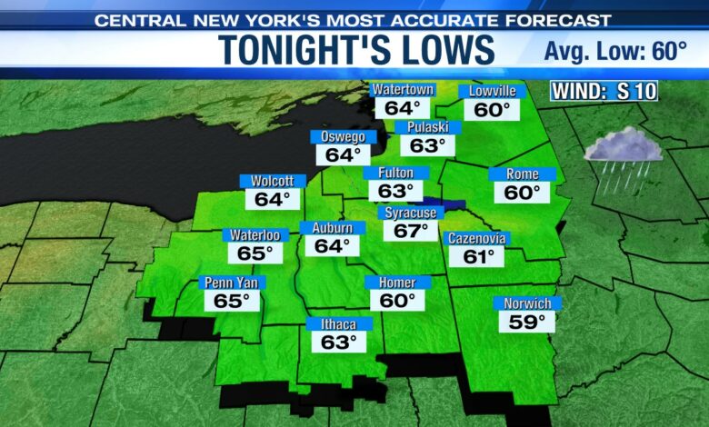
Not as cool overnight
Cloudy skies and a bit of a breeze overnight means it won’t be as cool over central New York as last night. Most areas will not see their temperatures drop below 60 degrees.
As the overnight wears I you can expect our chances for showers to increase as well.
Soggy start to the weekend
Saturday won’t be nearly as nice as the end of this week. Mugginess is returning on Saturday with a gusty southerly wind ushering in the higher humidity. At times, the winds gust past 30 mph in the afternoon.
That increase in humidity is going to raise our shower and storm threat for Saturday. It is important to keep in mind that the showers and storms won’t be limited to just the afternoon or evening.
There could even be some storms with gusty, damaging winds and hail by late afternoon and with all the moisture around there will be some heavy downpours which brings the possibility of localized flash flooding into the picture.
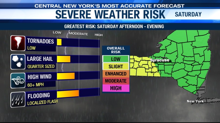
So be sure to be prepared to have backup indoor plans Saturday and or rain gear if you are taking part in outdoor activities on Saturday.
Click here for the Jazz Fest and marine forecast for Saturday
Sunday looking a bit better…
A cold front comes through late Saturday night/Sunday morning, but showers linger into Sunday morning before we see longer stretches of dry weather midday into the afternoon. We get the bonus of some sunshine, too, which should help us get into the low 80s before the day is done.
By Sunday evening, a weak trough of low pressure is ready to swing through with a few more showers but is departing by Monday morning. High pressure builds in to start the week with sunshine and seasonably mild temperatures.
Check out the latest 7-day forecast.


