
How much longer does out heat wave last?
A Heat Advisory remains in effect for all of Central New York until 8pm Thursday. Heat index values of 95 to 100 degrees are expected Thursday. Click here for the details.
- Wednesday was the hottest day, but it remains very warm/hot into weekend
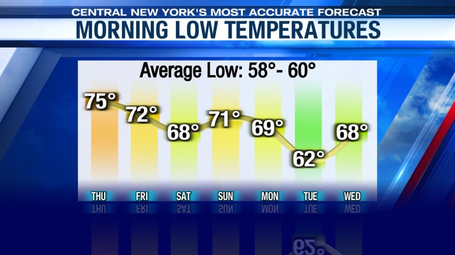
- Most nighttime low temperatures will not drop below the upper 60s and low 70s
- If you must be outside in the heat, take appropriate precautions
- Storms will be scattered right into the weekend but any storm that develops could produce damaging winds, hail and torrential rain that may lead to localized flash flooding
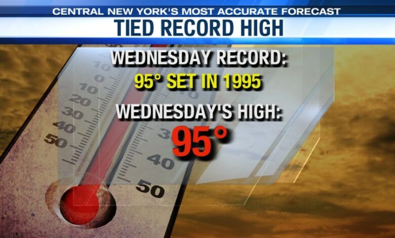
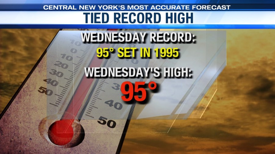
SYRACUSE, NY (WSYR-TV) – After record breaking warmth moved in to start the week Monday, and record tying warmth, 95°, Wednesday, the heat and humidity are going to ease a bit, but how much? Find out below…
First heat wave of 2024 continues…
Our first official heat wave of the year started Monday in CNY and is the first one in nearly 2 years. An official heat wave is defined as 3 or more consecutive 90°+ days in this part of the country.
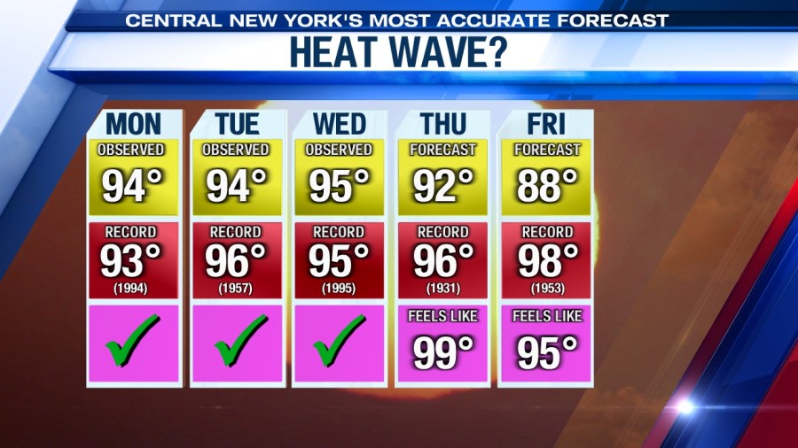
You can see why the National Weather Service issued a Heat Advisory with forecast high above still into the 90s on Thursday. A subtle drop into the upper-80s is on Friday and Saturday.
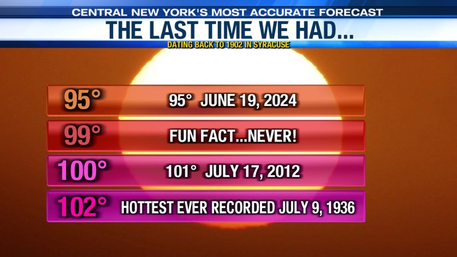
It has been a while since we have felt temperatures this hot. The last time we had a high of at least 95° before Wednesday was back in 2022. We haven’t had a temperature of 100° or hotter since 2012, which is not expected to happen in this heat wave.
Very stuffy overnights persist…
What makes matters worse is the fact that we don’t get a chance to cool all that much during the nights. We are going to continue the string of days where temperatures stay at or above 70 degrees throughout the overnight. Wednesday night, for the second night in a row, Syracuse probably won’t drop below the mid-70s!
This puts an extra strain on the air conditioning and fans and makes it a potential health risk to those that don’t have AC.
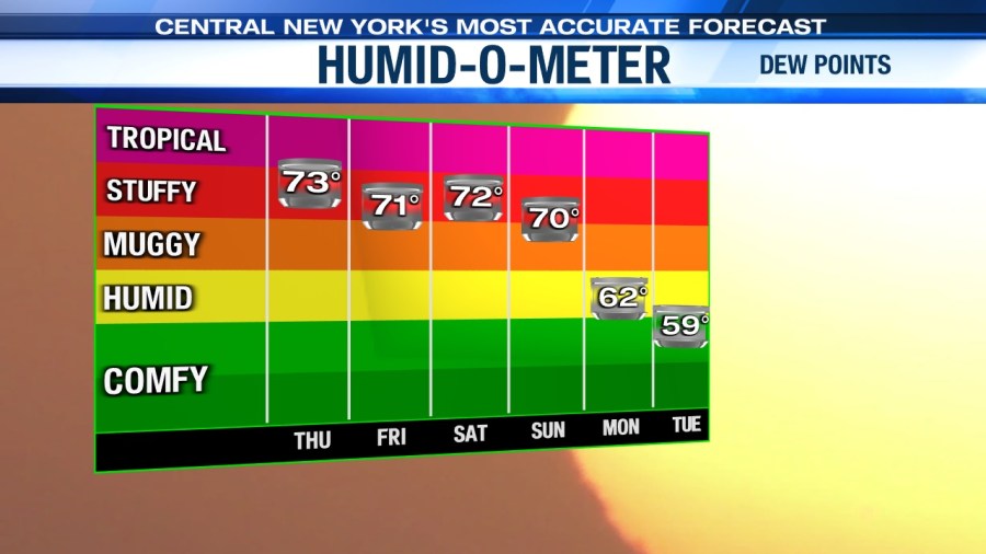
Not just hot, but humid too
On top of high temperatures being in the 90s for an extended stretch, we expect dew points to continue to range from the upper 60s to mid-70s for the most part, making it feel very steamy and even hotter/more oppressive right into the weekend.
Heat index values during the afternoon and early evening into Thursday will likely be up around 100° which can lead to heat exhaustion and even stroke if the proper precautions aren’t taken.
Tips for staying safe during the hot weather
- Do not leave children or pets in vehicles
- Drink plenty of water and avoid caffeine and alcohol
- Check on the elderly, very young and pets
- Dress in loose-fitting, lightweight, light-colored clothing
- Slow down outside and take frequent breaks if you have to work outdoors
- Avoid strenuous activities after 10 or 11 a.m. and before 7 or 8 p.m.
- Postpone outdoor activities
What about the rain/storm chances?
There haven’t been too many showers and storms this week, but we think the shower/storm threat and impacted area increases late this week into the weekend, especially Sunday afternoon and night. No, we do NOT think Friday, or the weekend will be a washout but be on guard and ready to duck inside if need be. How’s the weather looking for boating and mowing plans Thursday? Find out here.
Also, any storm that develops the rest of the week into the weekend could pack a punch with damaging winds and heavy rain possibly producing localized flooding.
Check out the latest 7-day forecast.


