Heat and humidity is not letting up just yet over CNY this weekend
- While the heat has peaked, it remains hot and muggy into the weekend
- Stalled front nearby means more scattered showers and storms Saturday
- Stronger cold front brings more widespread storms Sunday
- Real relief in the form of lower temperatures and dew points waits until Monday
SYRACUSE, NY (WSYR-TV) – We’ve one of the hottest and longest stretches of weather for this early in June. While the hottest temperatures of this current heat wave are over for central New York, but here are still some very warm and very muggy days to navigate into the weekend.
T-storms remain rather scattered…
While a few have had some heavy downpours from thunderstorms the last couple of days, for many (including Syracuse) it has remained bone dry. Don’t forget to water the plants!
A stalled front moves back north as a warm front Saturday and will provide the trigger for a few more scattered showers and storms. Again, areas south of Syracuse stand the best chance of getting wet.
Going to Polish or Pride fest or hosting a graduation party? Check out the forecast here.
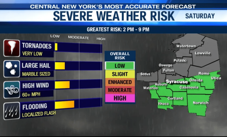
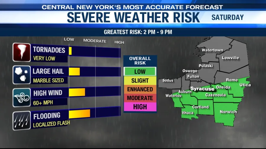
By the end of the weekend a stronger cold front is headed east from the Great Lakes and crosses central New York. That will take the fuel in the form of warmth (temperatures near 90° again) and high humidity (dew points near 70°) and create more widespread showers and storms.
We’ll have to keep an eye on these storms. A bit more wind shows up aloft than we have seen all week and that could increase our chances for severe weather.
When does the heat wave end?
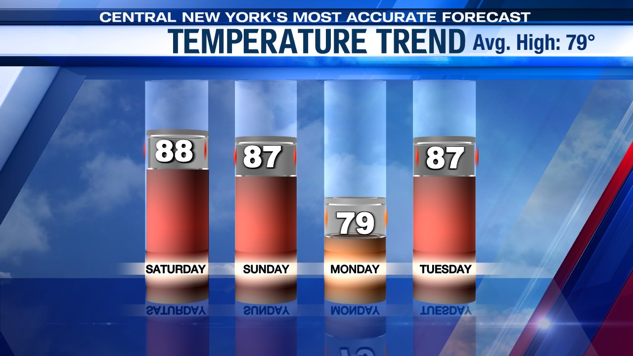
We dial back the highs the next couple of days into the upper 80s which is still quite warm for late June. That kind of warmth is with us through the weekend. So, while the heat is not as extreme, it is still going to be uncomfortable for many with no real relief coming until Monday.
A Heat Advisory is still in effect for Tompkins County until Sunday evening as heat index values could approach 100° Saturday and Sunday afternoon.
What does relief look like?
How about a day with temperatures in the 70s and lower dewpoints?
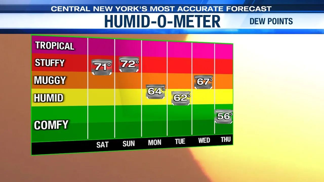
That’s what we’ll have on Monday. However, there is some moisture lagging Sunday’s cold front so watch for a few showers, perhaps some thunder as a tradeoff.
Tuesday is a drier day than Monday and temperatures are already rising back into the 80s but thankfully it should remain less humid with a mix of sun and clouds as high pressure dominates.
Check out the latest 7-day forecast.