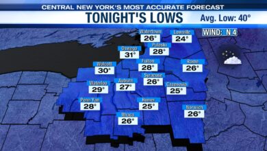
A bright and mild start to the week

SYRACUSE, NY (WSYR) – A milder than average start to the new week, and you’ll need the shades!
COMING UP THIS WEEK
As we head back to school and work Monday our weather will be nice under more sunshine, a bit breezy and milder. Highs warm into the mid to upper 40s.

HAVE UMBRELLAS HANDY MIDWEEK
Tuesday and beyond turns damp thanks to a system moving in late Monday night into Tuesday and stalling through midweek.
SNOW ANYTIME SOON??
In short, probably not. It stays too warm in the 40s and possibly around 50 most of this week. However, we could finally get some cold enough air in here next week for a chance to see some flakes…
LOTS OF UNCERTAINTY LATE WEEK…
We have a couple of longer range models we especially pay attention to when it comes to forecasting more than a few days out. At this time these two models are not agreeing with each other.
One set of data (the GFS model) has CNY getting soaked Friday into the start of the weekend.
The other (the European model) has the storm staying south of CNY keeping us high and dry and seasonably cool.
Stay tuned for updates through the week from the NewsChannel 9 Storm Team.
Powered by News Channel 9.