Few showers to kick off March

SYRACUSE, N.Y. (WSYR-TV) – Our weather remains somewhat active the rest of the week, especially as we inch closer to the weekend. Details below…
Stays active, but not as impactful mid-week
Another round of a wintry mix of wet snow and rain returns with a weak system later in the day Wednesday.
It’s mild when this system arrives, so we expect a mix of rain showers with some snow mixed in during the early afternoon. We would not be surprised if there was a brief burst of snow in the Syracuse area around 2 or 3 pm. While a light accumulation is possible over the Tug Hill.

There should be a brief lull before a few more few rain showers pass by late Wednesday night into early Thursday morning.
Much of Thursday ends up dry and mild. Temperatures could approach 50 south of Syracuse while we stay around 40 along and north of the Thruway.
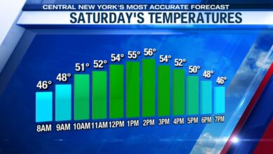
The next storm takes shape Friday into Saturday
We are watching the end of the week and the start of the weekend carefully as the next winter storm is expected to impact the region.
Confidence is growing we’ll see precipitation from our next storm to move into the area by Friday afternoon and linger early Saturday morning.
What will fall from the sky? We’re still working that out…
With enough cold air in place, we could see our next chance at accumulating snow for CNY and northern New York. However, milder air will not be that far away, so we are taking the next few days to analyze new data and work out the chances of snow versus a wintry mix across our viewing area. We’ll keep you updated!

Powered by News Channel 9.